Sat
25 Jul
31%
Activity
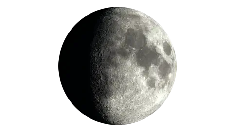
Moon Phase
waxing gibbous
Moonrise
1:16pm
Major Windows
8:28am – 10:28am
8:03pm – 10:03pm
Minor Windows
2:54am – 4:54am
12:16pm – 2:16pm
Fishing Times, Weather & Reports
Today's Wangaratta fishing forecast is based on the current solunar and weather signals. Light precipitation; often fishable with minimal impact.
Updated
Moon Phase
Waxing Gibbous
Estimated Fish Feeding Activity
31%
Possible bite intensity is 31%, suggesting quiet fishing conditions.
Daily Timing
Current data for Wangaratta place conditions in the quiet range at 31% potential bite intensity.
Solunar Score Today
31% Potential Bite (Feeding) Intensity
Major 1
08:28 – 10:28
Centre · 09:28
Strength · 12.5%
Underfoot transit major
Major 2
20:03 – 22:03
Centre · 21:03
Strength · 100%
Overhead transit major
Minor 1
02:54 – 04:54
Centre · 03:54
Strength · 28.1%
Moonset minor
Minor 2
12:16 – 14:16
Centre · 13:16
Strength · 21.6%
Moonrise minor
7 Day Solunar Forecast
Compare daily bite activity, major fish feeding times and moon conditions to help plan upcoming fishing sessions.
Weather
Conditions here can shift quickly through the day, so use this as the broad weather picture alongside the separate wind and pressure sections below.
Right now
Clear Sky
9.8°C
Today
Maximum
11.5°C
Minimum
6.5°C
Rain
0.4 mm
Sat
25 Jul
Light Drizzle
Range
6.5°C to 11.5°C
Rain
0.4 mm
Sun
26 Jul
Overcast
Range
4.6°C to 11.6°C
Rain
0.0 mm
Mon
27 Jul
Light Drizzle
Range
3.6°C to 11.9°C
Rain
0.1 mm
Tue
28 Jul
Moderate Showers
Range
5.8°C to 13.3°C
Rain
7.2 mm
Wed
29 Jul
Mainly Clear
Range
3.5°C to 11.9°C
Rain
0.0 mm
Thu
30 Jul
Mainly Clear
Range
0.2°C to 12.2°C
Rain
0.0 mm
Fri
31 Jul
Clear Sky
Range
0.3°C to 13.2°C
Rain
0.0 mm
Pressure
Pressure is most useful for fishing when it shows movement. A stable, rising, or falling trend can add context to the rest of today’s fishing forecast.
Right now
Interpretation
Pressure changes tend to matter more than the absolute value, especially when conditions are shifting.
Pressure is only one signal. Wind, tide, solunar timing, water movement, and local structure still matter.
Recent readings build the pressure trend used for interpretation.
Wind
Wind direction and strength can change how exposed a location feels, especially around open water, beaches, piers, and headlands.
Right now
Current speed
8.2 km/h
Direction
NW
Today max
10.4 km/h
Reading the wind
Wind direction and strength can affect comfort, casting, and exposure around this location.
Wind gusts can be stronger than the average wind speed, so it's worth checking the gust forecast if you're planning to fish from an exposed location or need to know about potential changes in conditions.
Even modest wind can affect comfort and casting, especially where the water is exposed.
The marker shows the current wind direction, while the daily outlook below shows whether conditions are likely to build or ease over the coming days.
Fishing Reports
Recent catch activity for this location.
Reports analysed
12
This year
11
This season
4
Species mentioned
6
Reported species
Wangaratta reports are led by Yellowbelly, Murray Cod and Carp.
The leading species here reflect report mentions within the region, not a full catch survey.
Based on regional Getfished fishing report species data.
* Note that report summaries will sometimes display the same species under different names. This is because they are being reported that way. This is intentional.
Share of the displayed top 5 species mentions for this location.
Yabbies, worms and jan juc worms make up most of what's been mentioned here.
It is a useful starting point, not a hard ranking.
Built from all-time reported bait mentions: 2480 mentions across 13 distinct bait entries.
Share of the displayed top 5 bait mentions.
Today's sunrise is 7:18 am and sunset is 5:23 pm. As a general guide, the hour before and after sunrise and sunset are often among the most productive fishing periods. No solunar period overlaps sunrise or sunset today, so the other listed bite windows may provide better timing guidance. Barometric pressure is rising, adding a potentially favourable signal.
Find out what we learned from analysing 20,000 fishing reports about moon times and fish.
Being a land-based location using berley is extremely imortant in order to bring the towards the fish towards location and into you.
Murray Cod, Trout Cod and Yellowbelly can be targeted at the location during summer. Activity is strongest for these species during the warmer part of the year. Actual catches will vary according to temperature trends, localised weather and tides.
Carp, Murray Cod, Trout Cod and Yellowbelly are a good choice for anglers to target during autumn. With the water temperature dropping the location provides an opportunity to concentrate on these species.
Murray Cod are the species to focus on because Winter is when the water drops below 15c and this location is no different. Fish can be slower to bite with reduced activity levels. As always what you catch varies with the prevalent temperature trends, localised weather and of course tides.
Wangaratta is right next to the Ovens and King rivers, so anglers can fish close to town or head out into the valleys.
Frank Garth Reserve is in the centre of Wangaratta where the two rivers meet, making it an easy spot for a quick session from the bank.
Northern Beaches is about 600 metres north of town and feels more secluded, with riverbank access and a swimming area nearby.
If you have more time, you can follow the King River through the King Valley and explore a much longer stretch of water.
Fishing near Wangaratta means targeting river junctions, undercut banks, logs, and boulders. Upstream, the water is clear and alpine, while closer to town it slows down. The Ovens River runs right through Wangaratta, so you don’t have to travel far, but the river changes quickly once you leave the urban area.
The King River stretches for over 100 kilometres through the valley, with grey stones and clear runs that feel different from the pools in town. Spring and early summer are good times to fish because the water is clearer and fish are more active. From May, colder water means fishing slower, as the fish are less active.
Structure should guide where to cast. In the town reaches, the river meeting at Frank Garth Reserve creates an obvious focus point, while Northern Beaches gives access to banks where logs and undercuts can hold fish close to cover.
Fly fishing is a practical option in parts of the Ovens near Northern Beaches, especially when working tight to holding water rather than simply casting into open flow. In the King Valley, moving between runs, boulder edges and quieter pockets is more useful than staying fixed in one place.
Murray cod, Trout cod and Trout seasonal closures affect when you are permitted to target these species and what you are legally allowed to keep.
This means current Victorian Fisheries Authority dates and rules should be checked before fishing.
Basic light gear is enough for much of the clear-water river fishing, with fly gear useful where casts need to land around banks and structure.
Reading bank shape, cover, flow and seasonal closures will matter more than carrying a long list of lures or bait.
No. Because a forecast cannot truthfully guarantee whether fish are biting at a specific spot right now. Getfished shows the current fishing conditions instead: tide movement, solunar timing, weather, wind, pressure, marine conditions and fising report, derived, species history.
Use this information to make informed decisions about where to fish, and to compare conditions across nearby locations. We hope you enjoy using Getfished to find your next great fishing spot!
✨Find out what we learned from analysing 20,000 fishing reports about moon times and fish told us.
| Latitude | -36.3561 |
|---|---|
| Longitude | 146.3099
View on Google Maps |
| Nearest city | Melbourne |
| Distance from Melbourne (as the crow flies) | 239.49 km |
| Platform | Land based |
| Rivers | Ovens river |
Nearby options
A small selection of other freshwater locations from the same region.
Region Locations
Possible bite intensity is 31%, suggesting quiet fishing conditions.
Air 8.8 C
Pressure 994 hPa
Sunrise 7:21am
Sunset 5:23pm
Updated 25 Jul 7:00pm
Showing 1–6
Fishing report summaries are derived from Getfished’s structured fishing report database system. More information on this on how we collect and structure fishing report data can be found on our Fishing reports information.
Forecasts are based on the Getfished Meteorological and Solunar Forecasting System, which combines data from the BOM, and other sources. Our custom software systems use these inputs to establish solunar, tides and other forecasts for fishing conditions.
For more information on our systems and data sources please see our Datasources page. You can also Contact us for more information or details on commercial reuse.