Sat
25 Jul
31%
Activity
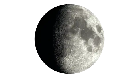
Moon Phase
waxing gibbous
Moonrise
1:16pm
Major Windows
8:29am – 10:29am
8:04pm – 10:04pm
Minor Windows
2:57am – 4:57am
12:16pm – 2:16pm
Fishing Times, Weather & Reports
Today's Lake Nillahcootie fishing forecast is based on the current solunar and weather signals. Light precipitation; often fishable with minimal impact.
Updated
Moon Phase
Waxing Gibbous
Estimated Fish Feeding Activity
31%
Possible bite intensity is 31%, suggesting quiet fishing conditions.
Daily Timing
Current data for Lake Nillahcootie place conditions in the quiet range at 31% potential bite intensity.
Solunar Score Today
31% Potential Bite (Feeding) Intensity
Major 1
08:29 – 10:29
Centre · 09:29
Strength · 13.1%
Underfoot transit major
Major 2
20:04 – 22:04
Centre · 21:04
Strength · 100%
Overhead transit major
Minor 1
02:57 – 04:57
Centre · 03:57
Strength · 30.9%
Moonset minor
Minor 2
12:16 – 14:16
Centre · 13:16
Strength · 21.3%
Moonrise minor
7 Day Solunar Forecast
Compare daily bite activity, major fish feeding times and moon conditions to help plan upcoming fishing sessions.
Weather
Conditions here can shift quickly through the day, so use this as the broad weather picture alongside the separate wind and pressure sections below.
Right now
Light Drizzle
8.8°C
Today
Maximum
12.4°C
Minimum
7.0°C
Rain
1.0 mm
Sat
25 Jul
Light Drizzle
Range
7.0°C to 12.4°C
Rain
1.0 mm
Sun
26 Jul
Light Drizzle
Range
5.0°C to 12.5°C
Rain
0.6 mm
Mon
27 Jul
Light Drizzle
Range
4.8°C to 10.1°C
Rain
0.4 mm
Tue
28 Jul
Moderate Drizzle
Range
6.4°C to 11.1°C
Rain
4.9 mm
Wed
29 Jul
Light Drizzle
Range
3.0°C to 10.4°C
Rain
0.2 mm
Thu
30 Jul
Overcast
Range
2.5°C to 10.2°C
Rain
0.0 mm
Fri
31 Jul
Clear Sky
Range
2.3°C to 11.9°C
Rain
0.0 mm
Pressure
Pressure is most useful for fishing when it shows movement. A stable, rising, or falling trend can add context to the rest of today’s fishing forecast.
Right now
Interpretation
Pressure changes tend to matter more than the absolute value, especially when conditions are shifting.
Pressure is only one signal. Wind, tide, solunar timing, water movement, and local structure still matter.
Recent readings build the pressure trend used for interpretation.
Wind
Wind direction and strength can change how exposed a location feels, especially around open water, beaches, piers, and headlands.
Right now
Current speed
2.4 km/h
Direction
S
Today max
8.3 km/h
Reading the wind
Wind direction and strength can affect comfort, casting, and exposure around this location.
Wind gusts can be stronger than the average wind speed, so it's worth checking the gust forecast if you're planning to fish from an exposed location or need to know about potential changes in conditions.
Even modest wind can affect comfort and casting, especially where the water is exposed.
The marker shows the current wind direction, while the daily outlook below shows whether conditions are likely to build or ease over the coming days.
Fishing Reports
Recent catch activity for this location.
Reports analysed
34
This year
4
This season
0
Species mentioned
4
Reported species
Yellowbelly leads the reports for Lake Nillahcootie, followed by Murray Cod and Carp.
This summary is based on reports tied to this location and is intended to assist using the species chart.
Based on local Getfished fishing report species data.
* Note that report summaries will sometimes display the same species under different names. This is because they are being reported that way. This is intentional.
Share of the displayed top 4 species mentions for this location.
Yabbies lead the way here, with worms and live shrimp not far behind.
It is a useful starting point, not a hard ranking.
Built from all-time reported bait mentions: 1202 mentions across 9 distinct bait entries.
Share of the displayed top 5 bait mentions.
Today's sunrise is 7:21 am and sunset is 5:23 pm. As a general guide, the hour before and after sunrise and sunset are often among the most productive fishing periods. No solunar period overlaps sunrise or sunset today, so the other listed bite windows may provide better timing guidance. Barometric pressure is rising, adding a potentially favourable signal.
Find out what we learned from analysing 20,000 fishing reports about moon times and fish.
Murray Cod, Redfin and Yellowbelly can be targeted at the location during summer. Activity is strongest for these species during the warmer part of the year. Actual catches will vary according to temperature trends, localised weather and tides.
Murray Cod and Yellowbelly are a good choice for anglers to target during autumn. With the water temperature dropping the location provides an opportunity to concentrate on these species.
Carp, Murray Cod, Redfin and Yellowbelly are the species to focus on because Winter is when the water drops below 15c and this location is no different. Fish can be slower to bite with reduced activity levels. As always what you catch varies with the prevalent temperature trends, localised weather and of course tides.
Spring sees the water temperature begin to rise with Carp, Murray Cod, Redfin and Yellowbelly becoming more active. Later in spring summer species such as Murray Cod, Redfin and Yellowbelly begin to move into the area and can become more common at the location.
Lake Nillahcootie is a smaller inland lake in the Broken River catchment and can hold up to 40,000 megalitres of water. The main fish you’ll find are golden perch (yellowbelly), Murray cod, redfin, and carp. Focusing on these species helps you pick the right bait and techniques. Fishing conditions change a lot as water levels rise and fall. When the lake is full, the best fishing is usually along the edges, where fresh water covers grassy margins and shallow flats. At these times, fishing from the bank works well, and you don’t need to take a boat or kayak far from shore to find good spots.
A good starting place is the boat ramp. Because it’s easy to get to and a bit deeper than other spots, it also tends to be the clearest part of the lake in terms of water clarity.
At Lake Nillahcootie, water clarity can be murky, but you can usually see about 40-50 cm down, so fishing is still good. Brightly coloured lures like chartreuse, orange, or pink, or natural colours like gold and silver, stand out better when the water isn’t clear. Worms and yabbies are good bait, and adding a small rattle or scent can help attract fish in cloudy water. The water near the ramp is usually clearer than the upper end because sediment settles in the deeper parts.
One of the best times to fish here is Spring. The water begins to warm up, and fresh inflows get the fish moving.
If it’s been a wet winter and spring, the lake fills over dry ground, creating new shallow feeding spots around regrown grass and flooded edges. Before you fish, make sure to first check for seasonal rules or closed seasons, especially for Murray cod, since they are sometimes protected during spawning. Knowing the rules helps you avoid breaking them by accident. Murray Cod season closure in Victoria is usually between September 1st and December 1st each year. This can change, so keep up to date with Vic Fisheries rules on their website.
Try fishing along the new edges; it usually works better than heading straight for deeper water.
If you’re fishing from the bank, use simple baits over the flooded ground. In a boat or kayak, anchor close to the bank and fish in water less than 2 metres deep. You don’t always need long casts; sometimes just dropping your bait right below the boat works well when fish are in the shallows. Grass is important because it gives fish food and cover, but it can also tangle your gear. Lures that go too deep often get stuck in the grass, so it’s better to use shallow-running, short-bodied trolling lures or lipless crankbaits that stay just above the bottom.
Basic tackle is all you will need to fish here. If you’re starting, a basic 6-7 foot spinning rod and a simple spinning reel with 6-10 lb monofilament line will work for most fish you’ll find in Lake Nillahcootie.
This is simple, easy-to-use tackle from the bank or a boat, and it’s more than enough for golden perch, redfin, and even smaller Murray cod. A basic tackle kit with a few hooks, sinkers, and some bright or natural lures is also a good way to get started.
Before you head out, make sure you have a valid Victorian fishing license, as most anglers need one here.e.
No. Because a forecast cannot truthfully guarantee whether fish are biting at a specific spot right now. Getfished shows the current fishing conditions instead: tide movement, solunar timing, weather, wind, pressure, marine conditions and fising report, derived, species history.
Use this information to make informed decisions about where to fish, and to compare conditions across nearby locations. We hope you enjoy using Getfished to find your next great fishing spot!
✨Find out what we learned from analysing 20,000 fishing reports about moon times and fish told us.
| Latitude | -36.8845 |
|---|---|
| Longitude | 146.002
View on Google Maps |
| Nearest city | Melbourne |
| Distance from Melbourne (as the crow flies) | 180.73 km |
| Rivers | Goulburn river |
| Lakes | Lake nillahcootie |
Fishing report summaries are derived from Getfished’s structured fishing report database system. More information on this on how we collect and structure fishing report data can be found on our Fishing reports information.
Forecasts are based on the Getfished Meteorological and Solunar Forecasting System, which combines data from the BOM, and other sources. Our custom software systems use these inputs to establish solunar, tides and other forecasts for fishing conditions.
For more information on our systems and data sources please see our Datasources page. You can also Contact us for more information or details on commercial reuse.